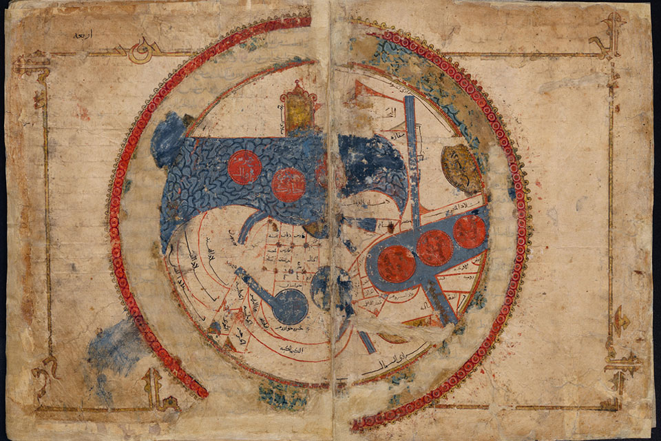
Why is South always on the top of medieval Islamic Maps? And why are the islands in the Mediterranean placed like pearls on a string in the middle? New book by Karen Pinto tells the story.
Medieval Islamic Maps: An Exploration
By Karen C Pinto
University of Chicago Press 2016
ISBN-10: 022612696X
ISBN-13: 978-0226126968
ABSTRACT
 Hundreds of exceptional cartographic images are scattered throughout medieval and early modern Arabic, Persian, and Turkish manuscript collections. The plethora of copies created around the Islamic world over the course of eight centuries testifies to the enduring importance of these medieval visions for the Muslim cartographic imagination.
With Medieval Islamic Maps, historian Karen C. Pinto brings us the first in-depth exploration of medieval Islamic cartography from the mid-tenth to the nineteenth century. Pinto focuses on the distinct tradition of maps known collectively as the Book of Roads and Kingdoms (Kitāb al-Masālik w’al- Mamālik, or KMMS). The book is also referred to in English as “The Book of Roads and Provinces” or “Book of Routes and Realms”.
The Book of Roads and Kingdoms is a 9th-century geography text by the Persian geographer Ibn Khordadbeh. It maps and describes the major trade routes of the time within the Muslim world, and discusses distant trading regions such as Japan, Korea, and China. It was written around 870 CE, while its author was Director of Posts and Police for the Abbasid province of Djibal. The work uses much of the Persian administrative terms and gives considerable attention to pre-Islamic Iranian history, uses “native Iranian cosmological division system of the world”. These all show “the existence of Iranian sources at the core of the work”. Another source of influence on the KMMS was Claudius Ptolemy, and Greek history.
Pinto examines the maps from three distinct angles – iconography, context, and patronage.
She untangles the history of the KMMS maps, traces their inception and evolution, and analyzes them to reveal the identities of their creators, painters, and patrons, as well as the vivid realities of the social and physical world they depicted. In doing so, Pinto develops innovative techniques for approaching the visual record of Islamic history, explores how medieval Muslims perceived themselves and their world, and brings Middle Eastern maps into the forefront of the study of the history of cartography.
TABLE OF CONTENTS:
Note on Transliteration
Chapter 1 Introduction: Ways of Seeing Islamic Maps
Chapter 2 A Look Back
Chapter 3 A Sketch of the Islamic Mapping Tradition
Chapter 4 KMMS World Maps Primer
Chapter 5 Iconography of the Encircling Ocean
Chapter 6 Classical and Medieval Encircling Oceans
Chapter 7 The Muslim Baḥr al-Muḥīṭ
Chapter 8 The Beja in Time and Space
Chapter 9 How the Beja Capture Imagination
Chapter 10 Meḥmed II and Map Patronage
Chapter 11 The KMMS Ottoman Cluster
Chapter 12 Source of the Ottoman Cluster
Chapter 13 Conclusion: Mundus est immundus
Acknowledgments
Notes
Bibliography
Index
ABOUT THE AUTHOR:
Joining the Boise State faculty for the Department of History, Dr. Karen C. Pinto specializes in a number of historical areas particularly Islamic cartography and Middle Eastern History. She earned her Ph.d, M.Phil, and M.A. in History from Columbia University, and has taught at the Gettysburg College and The American University of Beirut. She has participated in a number of college workshops including such topics as digital humanities, student research, and of course Middle Eastern Studies. Dr. Pinto’s professional service includes being a review panelist for the NEH, and peer-reviewing articles for “Al-Qantara and “Medieval Encounters”. Her new book “Medieval Islamic Maps: An Exploration” will be published by the University of Chicago Press in 2016 and she received a National Endowment for the Humanities Fellowship for 2014-15 to work on a book project on “The Mediterranean in the Islamic Cartographic Imagination.” Dr. Pinto offers courses on Islamic History, Ottoman History, US-Middle East History, Mediterranean Encounters, Islamic Civilization, and Map History.
FEATURED PHOTO:
World map, with South on top, “Ṣūrat al-Arḍ” (Picture of the World), from an abbreviated copy of al-Iṣṭakhrī’s “Kitāb al-masālik wa-al-mamālik” (Book of Routes and Realms). Leiden University Libraries. Cod. Or. 3101, fols. 4b–5a. Source: Wikipedia
READ MORE: