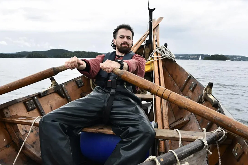
For three years, the archaeologist Greer Jarrett and his crew sailed up and down the coast of Norway in an old clinker-built Viking boat mapping the maritime mindscape of the Northmen
The Norwegian state, Norway, derives from the sailing route along the coast known as the Norðvegr. A recent paper explores this Norðvegr and its maritime mindscape as a lived experience.
What did it feel like to travel long distances in an open, clinker-built Viking boat along the Norwegian coast at the turn of the first millennium, when Cnut the Great ruled north-western Europe from Newfoundland to Sigtuna in Sweden? How did it all hang together? One of the preconditions was, of course, the technology – the Viking ships and boats, their oars, sails and rigging, the hardtack, and all the other paraphernalia involved. However, another was the knowledge of how to make way: the maritime mindscape. In terms of archaeology and literary studies, this is certainly not an unexplored field. An important contribution, however, has been the experimental archaeology carried out since the first recreation of a Viking ship set sail for Chicago in 1893. Most of these voyages have had the character of large-scale enterprises involving reconstructed ships based on the famous larger vessels discovered in Norwegian burial mounds or in the Firth of Roskilde.
Recently, though, experimental voyages have taken on another, and perhaps less spectacular, character: charting and exploring parts of the Norðvegr, which formed part of the via franca of the north-western European realm. What was the feasibility of travelling up and down the Norwegian coast in the small, ordinary, day-to-day clinker-built ships of yesteryear?
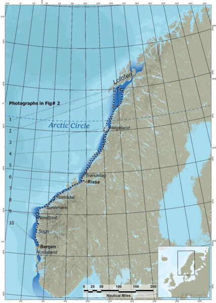
Greer Jarrett and his crew have explored this question “through experimental and ethnographic fieldwork onboard traditional Norwegian boats, focusing on aspects of Viking Age route choice, risk judgement, and the location of possible anchorages and harbours”. The goal has been not only to discover where people travelled, but also, through the identification of small harbours, to reconstruct concrete maritime itineraries along the Norwegian coast. In 2022, the sailing boat – an open, square-rigged clinker vessel modelled on those used during the Viking Age (800–1050 AD) – made a journey from Trondheim to the Arctic Circle. Since then, Jarrett and his team have sailed more than 5,000 km along historic Viking trade routes.
His research suggests that Viking voyages often took place well offshore, challenging earlier assumptions about their navigation methods. Simply put, navigating close to the coast appears to have been more unpredictable, as underwater currents and winds descending from the mountains created more complex sailing conditions. In short, the idea that Viking ships and boats sought to “hug the coast” is a myth. Putting out to sea was, in many cases, a better option. Over time, the Vikings became thoroughly accomplished seafarers. In an earlier study, Jarrett and his colleagues showed that, during the Middle Ages, Greenlanders could use this type of boat to reach remote areas of the Arctic in search of walrus tusks, while interacting with Inuit communities in the High Arctic.
Another conclusion is that the concrete experience of the preferability of the open sea helps to explain the location of the royal manors linked to the sea-king, Harald Fairhair, in Hordaland, which display a marked preference for outlying coastal areas. It may also explain why populations in inner Norway, hit by the climatic downturn after AD 536, moved westwards to the sea rather than maintaining settlements in the interior peninsula.
The Maritime Mindscape
One result has been the identification of four long-forgotten landing sites awaiting archaeological excavation. It is hoped that they will yield information about jetties, ballast stones, cooking pits, shelters, dung heaps, and other material remains – lost coins, amulets, and so forth.
However, one of the most important results of the research has been the identification of a cultural commonality which Jarrett has termed “the Maritime Mindscape”, or more precisely, “the Maritime Cultural Mindscape”. Put simply, the research has uncovered the practical seamanship underpinning the performance of this Maritime Mindscape, which was shared by people across the north-west and is also reflected in the literature (Jesch 2015), in mental geography (Jackson 2009), and in place-names signifying shipyards and landing sites (Stylegar 2002). Some Icelandic texts, such as Landnámabók, include passages that may be read as straightforward land- and sea-marks, so-called landkenningar.
The research has also shown that navigation was indeed possible – even across the open sea – without technical instruments. Seafarers well versed in this traditional lore would have been highly prized. In this respect, however, the recreated experience can never be entirely precise.
For reasons of safety, one “experience” was not explored: ignoring the weather forecast. Nor was the need to avoid actual Vikings – that is, pirates – part of the agenda. Moreover, relative sea level in 2022 differs from that of 1,200 years ago. Post-glacial land uplift would have resulted in a coastline that today lies approximately 3–5 metres below the level known from AD 1000.
PHOTOS:
Lund University and Greer Jarrett.
SOURCES:
Maritime Mindscapes: using experimental archaeology to reconstruct Viking Age seafaring routes
By Greer Jarrett
In D. Dangvard Pedersen, & J. Hansen (Eds.): Travelling Viking Age: Proceedings of the 40th Interdisciplinary Viking Symposium. Odense, University of Southern Denmark, May 3, 2023 (pp. 8-23).
(Kulturhistoriske studier i centralitet – Archaeological & Historical Studies in Centrality; Vol. 11). Forskningscenter: Centrum – Museum Odense – University Press of Southern Denmark
The lore of the leið: Tracking Viking Age voyages through traditional seafaring.
By Greer Jarrett
Acta Archaeologica Lundensia Series Altera in 8°, No 77
Doctoral Thesis (compilation), Department of Archaeology and Ancient
History, Lund University (2025).
From the Masthead to the Map: An Experimental and Digital Approach to Viking Age Seafaring Itineraries.
By Greer Jarrett
Journal of Archaeological Method Theory 32, 42.
The Threatening Wave: Norse Poetry and the Scottish Isles
By Janet Jesch
In: Barrett, J.H., Gibbon, S.J. (Eds.), Maritime Societies of the Viking and Medieval World. Routledge (2015)
Leeds, pp. 320–332.
Place-names as evidence for ancient maritime culture in Norway
By Frans-Arne H Stylegar
Årbok Norsk Sjøfartsmuseum 2002, pp 79-115
Ways on the “mental map” of medieval Scandinavians,
By T. N. Jackson
in: Heizmann, W., Böldl, K., Beck, H., Schier, K. (Eds.), Analecta Septentrionalia: Beiträge Zur Nordgermanischen Kultur- Und Literaturgeschichte. De Gruyter, Berlin, pp. 211–220.