New method overlaying old and modern maps reveals what the medieval landscape in Denmark might have looked like.
Historic maps as source for hydrological reconstruction of pre-industrial landscape wetness in Denmark: a methodological study
By Jens-Bjørn R. Andresen & Søren M. Kristiansen
Århus 2023
The traditional way to explore medieval landscapes has been to exploit pollen analyses. Significant issues with accuracy and the need to recover a more precise topographical layout are challenging when trying to grasp how people experienced their surroundings in earlier times. A new method shows that local economic maps from late 18th century Denmark allow us to get a sense of the topographical details necessary to understand better local features such as defensibility, sacredness, economic viability and more.
Denmark – a wet, moist, and damp landscape?
What a blessedly dreadful rain,
the air is streaked with crosses and lines,
the earth with a thousand streams.
Cool sparkling balls of raindrops,
thrown down with playful force,
shattering into a thousand sprays.
Drops part to melt together,
while tiny waves wildly tumble,
covering all with a murky sea…
(Hvilken velsignet forskrækkelig Regn af J. P. Jacobsen †1885. My translation)
Right now, leaves are dripping with rain as the moistness streaks down the trunks of the trees, and farmers loudly voice their frustration over the poor quality of the harvest. But where does all the water flow? Well, the answer is that a significant portion of it is drained away from fields and forests, only to be released into the rivers, lakes, firths and sea. We know that this release of water isn’t healthy for the state of the sea. Along with the running water follows a significant discharge of nitrogen, contributing to Denmark’s decline as a fishing nation. Additionally, the restoration of wetlands is a prerequisite for the recovery of robust ecosystems that will ensure our biodiversity improves.
However, it’s not as simple as just “letting the waters flow,” as many of us might dream of. What happens to the people whose backyards are at risk of flooding? And what happens to the farmers whose fields could be underwater? And more precisely, what did the landscape look like before we started draining it, causing frogs and, with them, storks to disappear?
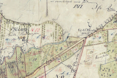
In truth, we can’t know for sure because water always finds its way. In that sense, the landscape of the past isn’t something that can easily be recreated. BUT: We can get some ideas by studying historical maps. A report has just been published on this topic, authored by cultural historian Jens Bjørn Andresen and geologist Søren M. Kristiansen, both from Aarhus University, demonstrating how the layering of older maps provides us with a sense of the topography.
More specifically, the researchers have developed a method to combine information from various maps – the high-resolution topographic maps as well as the redistribution maps from the period of land reforms in the 18th century. This map material may also be compared with the cadastre from 1688 and the information it contains. The method was developed based on an in-depth study of 100 km² in Eastern Jutland, more precisely, the catchment area along the 12 km long Giber Stream south of Aarhus, covering 40 km². The study shows a close correlation between, on the one hand, the markings on the old land distribution maps and their indications of where meadows and swamps were located and, on the other hand, the contour lines on the later topographic maps from the 19th century.
This method now provides an excellent insight into the pre-industrial mosaic landscape before 1800, and it can be reasonably inferred that this landscape remained stable for over 3000 years. Another key conclusion is that before 1800, more than a quarter of Denmark was unsuitable for agriculture. The rest was a mixed mosaic landscape filled with fields interspersed with small wet lakes and marshy areas, which only began to be utilized more seriously after 1853 when drainage pipes were invented. At this point, the agricultural land was also levelled with soil from everything from dolmens to old hedges. Often, these features may be detected in the old maps.
Today, over 90% of the old landscape’s wetlands have disappeared, which has drastic consequences for the last fragile remnants of biodiversity as well as the landscape’s capacity to absorb CO2. The new method provides a fairly reliable way to visualize how the landscape of the past appeared – which, all things considered, is a good indicator of where future wild natural areas should be restored.
More importantly, though, for medievalists, is the opportunity to come to grips with the past landscapes – whether wet, grazed, cultivated, or lived-in.
Karen Schousboe
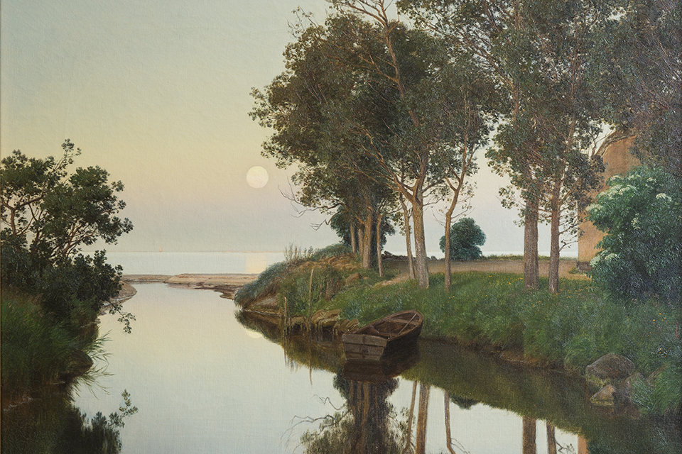
Featured Photo: Giber River in a summer evening. By Janus la Cour 1892. Aarhus City Hall. Source: Wikipedia