In AD 1362, a terrible storm broke through the dykes in the Wadden Sea, protecting medieval people living in the marshy foreland. Later called the Grote Mandrenke – The Great Drowning of Men – a whole town, Rungholt, together with 42 parishes, disappeared. New research explores the layout of the town.
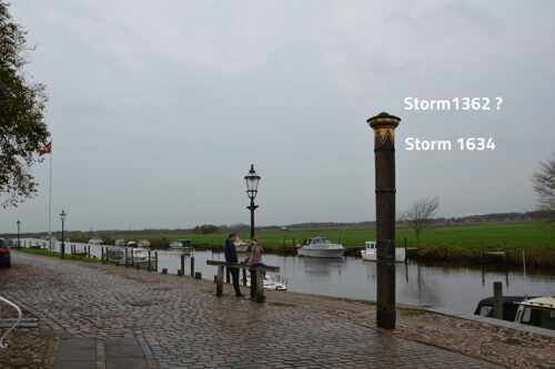
This winter, we experienced a terrible storm in Northwestern Europe, whipping up winds not seen in the last thirty years. This time, the storm hit England and Scotland the worst. However, with such winds, we never know where they head. Sometimes the storms reach their maximum when sweeping the coastline of Norway and Denmark. Whipping in from the northwest, they might occasionally turn and be fed from the south. When this happens, tidal water is packed into the Wadden Sea, testing the dykes to their utmost. Fortunately, this did not take place in 2022. The last time was in 1999 when the sea level reached 5,12 metres above the usual level, breaching the dykes at Rejsby and Ballum in Denmark. Luckily, the storm maxed out at low tide. Had it happened six hours later, a regular catastrophe would have taken place in all of Northern Frisia and Southern Denmark. In 1634, the Pillar of Storms (stormflodssøjlen) in Ribe measured the height of the worst storm ever, approximately more than 6 metres above usual sea level. In 1999, the forecast told us higher levels might have been the outcome.
Grote Mandrenke

We do not know precisely how high the water level was during the terrible storm in AD 1362. However, we know that large swathes of the marshy lands of Northern Frisia – called the Uthland – irrevocably sunk beneath the sea. Historians have estimated that perhaps 10.000 people lost their lives during that fateful night in October. Happening a few years after the Black Death had wiped out between 30-40% of the population, it must have experienced as if the apocalypse had finally arrived. Likely, no more than 400-450.000 people lived in present Denmark in the 15th century.
Many of the flood victims would have lived in mythical Rungholt, a thriving town located out in the low-lying marshes. When the tide is low, remains may still be seen of dykes and terps (warfts) southwest of the small Hallig Südfall between the islands of Pellworm and Nordstrand. According to written documents and archaeology (counting the number of wells), the local farmer and historian Andreas Busch
have estimated the number of inhabitants to be 1500-2000, perhaps a third of the people living in Hamburg at the same time. Trading in salt, amber, cattle and grain Rungholt was a thriving part of the commercial network between north Germany, Flanders, England and Scandinavia. Likely, people lived on a rich diet consisting of prawns, oysters, flatfish, waterfowls, their eggs and sea plantain, as well as sheep, cattle, and grain. A more lush landscape is difficult to imagine.
Since the Wadden Sea was inscribed as UNESCO World Heritage in 2009 and 2014, interdisciplinary research has been carried out by scientists, historians and archaeologists to understand these events better. Recently, a report was published outlining the archaeological remains of Rungholt like dykes, drainage ditches, terps (warfts or dwelling mounds) – and even plough marks. Today, these remains of the town “provide evidence of the once cultivated marshland”. Discovered and identified as Rungholt in the 1920s, we now know more of the small but thriving town.
The medieval foundation of Rungholt
The preconditions for the settlements in the marshy and amphibian foreland of the Wadden Sea ultimately depend on the paleographic evolution of the Frisian coast caused by the rising sea level after the last Ice Age. Leaving behind a low tidal landscape filled with brackish lagoons, the silting gradually provided a fertile landscape of low-lying marshland and tidal creeks, luring people to settle. Building terps and cultivating the fens, wealth and independence was secure to those who dared to move into the marshes. Typically, such waves of migrations took place during warm and welcoming weather periods – the Roman Optimum and the Carolingian centuries. Although uses of the fenlands in the late Neolithic and the Bronze Age have also been documented, the first permanent settlers took to the land during the Roman Empire.
In the 10th and 11th centuries, the favourable and warm climate led to a series of expansionary and migratory movements in Europe. One of these targeted the outlying marshlands bordering the Wadden Sea, culminating when Frisians settled, creating a vibrant landscape in the 12th and 13th centuries. The wealth of these settlers are documented from the finds of imported goods from the Rhineland, Flanders and even Spain – as pottery, metal vessels and weapons. Living on terps or warfts, the town operated a proper harbour secured by two wooden tidal gates dendrochronologically dated to c. 1331, the remains of which have been observed and studied. The base of the surrounding dyke has been measured to 25 to 30 metres and 1.6 to 2 metres high. The tidal gates are comparable to those from the medieval harbour of Rotterdam. Some terps held dwellings and storehouses, other farmsteads.
One of the preconditions for living in the tidal marshes at this point was the construction of dykes protecting the reclaimed farmland forming polders or koogs (kogs and groden). In addition, a well known and valued product of the marshes was salt cooked from brackish waters through the exploitation of peat extraction. With the use of peat for soil improvement, the building of terps and dykes and draining, a lowering of the land finally opened up for the catastrophes following the deterioration of the weather, which set in at the end of the 13th century. Eventually, this led to the great flooding events in the 14th century – in the Uthlands as well as along the European rivers.
Recent studies

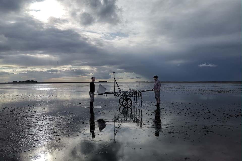
German North Frisian Wadden Sea.By Dennis Wilken et al. In Plos one 2022. By kind permission of Dennis Wilken (https://doi.org/10.1371/journal.pone.0265463.g002)
From the deployment of dendrochronology in the 19th century to the use of Lidar in the 1970s and gathering information from aDNA studies in the last decade, archaeologists have been busy expanding the use of scientific instruments and technologies to unveil the lived experience of people in the past. Hitherto prospecting such sites as Rungholt has involved the use of divers performing geophysical and geoarchaeological prospection. In the new study, however, the scientists have worked to collect magnetic gradiometry data, marine reflection seismic data, percussion cores samples and aerial photos to map the remains of Rungsholt revealing fascinating new information about the construction of Rungsholt with its harbour and dykes.
Thus, they have been able to reconstruct where the dyke ran, how the dwelling mounds were connected to the dyke and where fields and pathways were laid out in our area of investigation. Also, the scientists have shown that the dyke surrounding the town was higher than those of the terps. When the dyke broke in October 1362, the terps were flooded and people drowned.
FEATURED PHOTO
Wadden See. The Geomagnetic team at work on the tidal flats near Hallig Hooge. © Ruth Blankenfeldt, Centre for Baltic and Scandinavian Archaeology (ZBSA)
SOURCE:
PRESS: Submerged settlements in the Wadden Sea
By Kerstin Nees
University of Kiel 2021
Lost in the North Sea—Geophysical and geoarchaeological prospection of the Rungholt medieval dyke system (North Frisia, Germany)
Dennis Wilken , Hanna Hadler, Tina Wunderlich, Bente Majchczack, Michaela Schwardt, Annika Fediuk, Peter Fischer, Timo Willershäuser, Stefanie Klooß, Andreas Vött, Wolfgang Rabbel
Plos One (2022) April
Geoarchaeological evidence of marshland destruction in the area of Rungholt, present-day Wadden Sea around Hallig Südfall (North Frisia, Germany), by the Grote Mandrenke in 1362 AD
By H.Hadler, A.Vött, J.Newig, K.Emde, C.Finkler, P.Fischer, T.Willershäuser
In: Quaternary International
Volume 473, Part A, 15 April 2018, Pages 37-54
Quaternary International
READ ALSO:
Drowned by the Grote Mandrenke in 1362
New geo-archaeological research on the late medieval trading centre of Rungholt (North Frisia)
Hanna Hadler, Dennis Wilken, Tina Wunderlich, Annika Fediuk, Peter Fischer, Michaela Schwardt, Timo Willershäuser, Wolfgang Rabbel and Andreas Vött
In: Waddenland Outstanding: History, Landscape and Cultural Heritage of the Wadden Sea Region
Ed, by Linde Egberts
Meindert Schroor
Amsterdam University Press 2018

The sunken trade centre of Rungholt – Geophysical investigations in the German North Frisian Wadden Sea
Michaela Schwardt, Dennis Wilken, Hanna Hadler, Annika Fediuk, Tina Wunderlich, Andreas Vött,
Wolfgang Rabbel

In: New Global perspectives on Archaeological Prospection. 13th International Conference on Archaeological Prospection 28 august to 1. September, Sligo Ireland. Archaeopress Publishing Ltd 2019