In a new article, Michael Livingston generously allows us to follow in his footsteps while he studies the layout of the battleground of Agincourt
A Battle Is Its Ground: Conflict Analysis and a Case Study of Agincourt, 1415
Michael Livingston.
In: Journal of Medieval Military History, Vol 21
Boydell Press 2023
It may seem strange that we are not always quite sure where and how decisive battles were fought. This goes for ancient battles such as Thermopylae and Adrianapole. But the complication also plays a role when we try to understand how the battles at Crecý and Agincourt played out. In a new study published by Michael Livingston, he tackles not only the contested question of where Agincourt took place but also how to approach this question.
According to Livingston, terrain plays a significant role for contestants staging major decisive battles. Hence, to understand medieval warfare, we have to be sure where battles were engaged. One of the ways we might approach this question – archaeology – does provide solutions, as battles tend to leave troves of residue. For instance, this has been the case at Bosworth, where archaeology has been decisive in the understanding of the terrain and the events as they played out. Not so at Crecý and Agincourt, where the exact locations of the battlegrounds have been disputed for centuries.
“The Battle is its Ground”
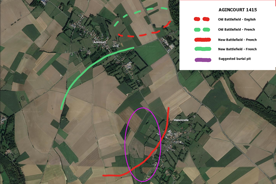
The first step is to identify the story as we agree upon it. According to this, Henry V took position on the Northern side of the village of Maisoncelle, where he faced a significantly larger French adversary. To engage with his reluctant enemy, he moved the English army into the narrow belt between the forests lining the outskirts of Azincourt and Tramecourt. From here, he was able to bait the French by sending a volley of arrows. As the ground was narrow and muddy, the French lost their advantage in numbers. The problem is – of course – we don’t really know where these forests were located.
The question, then, is how this description fits the terrain. To this end, Livingston introduces us to the mapping of Google Earth Pro, which allows us to study the topography as it looks today. However, we also need old maps to identify old road systems, the run of rivers, springs and brooks, swampy grounds, mill ponds and the like. Also, such maps might indicate the borders of ancient fields, field walls, wood pastures, and hedgerows. Likewise, these maps may record field names, such as the “Anglais”, which Livingston has identified as the place where Henry V camped the night before the battle.
Further, the argument involves carefully considering the number of men lined up for battle. Also, some concerns about the need for manoeuvring of these men must be calculated. Here, the experience gathered from experimental archaeology is invaluable.
The Reconstruction
With these three tools at hand: A formal description of what went on, how many people were engaged and how much room to manoeuvre was needed, and the reconstructed map of the traditionally identified battleground, Livingston is now able to point out that the battle could not have taken place there for the simple reason that there would not have been enough room for Henry to set his trap. “The traditional site appears too narrow to fit even the smallest possible raw numbers of soldiers on the English side”, Livingston writes.
This conclusion has to be held up against the fact that despite significant fieldwork in 2015, nothing attributable to the battle has been found on the assumed battlefield. A more likely suggestion is a site located to the south and west of the traditional assumed battlefield location, Livingston concludes. This location also points out the likely site for the large burial pit, which sources agree was the final resting place for most of the 5000 French soldiers said to have perished in battle. “Start digging”, Livingston writes.
However, the main point in this fascinating identification of a new possible site for the battle is not just the new location pointed out but rather the detective story leading up to the conclusion. The arguments are carefully spelt out and invite all visitors to go and have a look.
Finally, one more point should be made: This article is a splendid example of how diligent and close readings of texts and maps pared with topographical and archaeological surveys may lead us to a more clear understanding of what went on that fateful day in 1415, when yet another French army was once more sent to the ground.
READ ALSO (recent or soon to be published arrivals)


